Prevent deforestation with digital geodata management
At a glance
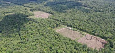
Forests around the world are being threatened by deforestation. Digital geodata management is helping authorities in Ecuador and Laos to better protect the forest against illegal deforestation.
The burning Amazon rainforest in Brazil made headlines worldwide. The tropical rainforest is also being threatened by the expansion of livestock farming and agriculture as well as mining in neighbouring Ecuador. And yet, forests, as carbon reservoirs and the natural habitat of many threatened species of animals and plants, play a key role in the fight against climate change and the extinction of species.
The Ecuadorian Health Ministry previously had insufficient resources to combat illegal deforestation. As a result, the KfW, on behalf of the Federal Ministry for Environment, Nature Conservation and Nuclear Safety (BMU), supported the establishment of a forest monitoring system with an investment of EUR 5.5 million between 2017 and 2019, which significantly improved the data situation on deforestation.
Digital remote sensing in the Ecuadorian Health Ministry
This is based on satellite recordings that are then refined using complex techniques. New high-quality hardware has made data processing possible in Ecuador. Ministry staff received training and introduced new collaborative processes for data analysis.
The improved geodata management in the ministry helps park rangers in the northern section of the Amazon rainforest. “Work as a park ranger is difficult and, in some cases, highly dangerous. The project allows rangers to detect deforestation with an accuracy of one hectare,” explains Alexandra Mylius, responsible KfW project manager.
Previously, forest controls were only able to uncover illegal deforestation based on public information or inaccurate satellite images. Today, updated data from the most remote parts of the rain forest is sent to their tablets every two weeks – a huge leap forward. This enables rangers to specifically seek out deforested locations, take photos and record GPD data, a critical step for reporting illegal deforestation. “The new forest monitoring allows park rangers and staff at Ecuador’s Environment Ministry to work much more effectively and efficiently,” assures Mylius.
Digital remote sensing with the help of satellite images and GPS data is also expected to prevent continuing deforestation in Laos. Increasing swathes of forest are having to make way for large infrastructure projects and illegal deforestation in the South-East Asian nation.
The 150 microsatellites collect images that can even record the felling of individual trees. In addition, a marking system along the entire production chain documents the origin of individual pieces of timber. The aim is to prevent wood from illegal forest clearing from reaching international trade. The KfW is implementing the project, which is part of the EU’s “Forest Law Enforcement, Governance and Trade” (FLEGT) initiative, with funding of almost EUR 20 million, on behalf of the Federal Ministry of Economic Cooperation and Development (BMZ). The funding includes the financing of training sessions in the forestry sector as well as the provision of the necessary equipment.